Creator Record
Metadata
Name |
Gambs, Robert N. |
Related Records
-
2019.1.0 - Gambs, Robert N. photography collection.
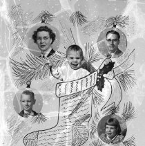
Gambs, Robert N. photography collection. See Record 2019.1.00 for info about more Gambs photos added in March 2023. In 2019 the survivors of photographer Robert N. Gambs (1-12-1917 to 7-19-1996) donated over 1000 of his negatives and prints and other mementos to the Baker County Library. The photo you see at upper right is one of 18 Gambs family photos attached to this record. The first one is in the form of a Christmas card from 1943. The c...
Record Type: Photo
-
2019.1.00 - Gambs, Robert N. photography collection.
Many more Robert Gambs negatives were processed in March of 2023. They are added to the Gambs Family collection starting with record 2019.1.419. At that time the new images were separated into 13 categories. In the future the original 408 records may be redistributed to these 13 categories. (But don't hold your breath; that job will take a lot of time. grd) 1. Agriculture 2. Baker City businesses 3. Baker City streets 4. BHS plays and mu...
Record Type: Photo

-
2019.1.1 - Pleasant Valley School students, Hazel Jeffries, Teacher. 1946.
Pleasant Valley School students, Hazel Jeffries, Teacher. 1946. Back Row: Joy Freeman, 7th grade; Lois West, 6th; Virginia Lambert, 6th; Patricia Fickett, 8th, Wilma Francis, 6th; Del Francis, 3rd; Hazel Jeffries, Teacher. Front Row: Jessie Ackerman, 1st; Emma Ackerman, 1st; Riley Freeman, 5th; Barbara Lee, 3rd; Ruth Lewis, 2nd; Gloria West, 1st. Barbara Lee's dad operated the store and built the motel.
Record Type: Photo

-
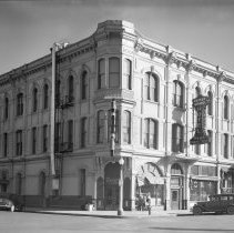
2019.1.10 - Geiser Grand Hotel ca. 1946.
Geiser Grand Hotel ca. 1946. The cupola has been removed. The Geiser Club entrance is at the corner, hotel entrance on Main, and Western Union office one door south.
Record Type: Photo
-
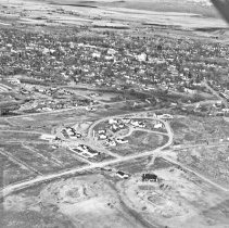
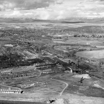
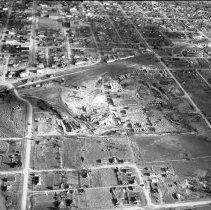
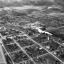
2019.1.100 - Aerial view of Baker City. Oregon Lumber Co.
Aerial view of Baker City. Oregon Lumber Co.
Record Type: Photo
-
2019.1.101 - Aerial view of Baker City. South and east side of town.
Aerial view of Baker City. South and east side of town from Oregon Lumber Co. to the hills north of town. Note that Mt. Hope Cemetery is at middle right edge of photo.
Record Type: Photo
-
2019.1.102 - Aerial view of Baker City. Oregon Lumber Co. and S Baker.
Aerial view of Baker City. Oregon Lumber Co. and S Baker. The two streets coming S to the bottom of the photo are 3rd on the left and 2nd down the middle. Between the stacks of lumber in top third of photo and the lumber mill is a long log pond filled with logs.
Record Type: Photo
-
2019.1.103 - Aerial view of Baker City. Oregon Lumber Co. and S Baker.
Aerial view of Baker City. Oregon Lumber Co. and S Baker. Mt. Hope Cemetery partly visible in upper left corner.
Record Type: Photo
-
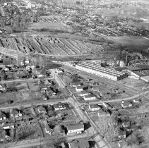
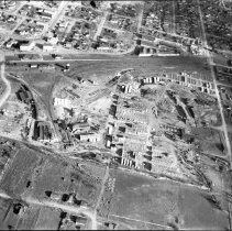
2019.1.104 - Aerial view of Baker City. Ellingson & Burnt River lumber companies.
Aerial view of Baker City. Ellingson & Burnt River lumber companies. Auburn St. and Court St. run W from about 7th St.
Record Type: Photo
-
2019.1.105 - Aerial view of Baker City. Broadway St. is near left edge.
Aerial view of Baker City. Broadway St. is near left edge. Broadway runs between the two large white building--Crabill and Columbia hotels. Until the U.P. Depot was demolished in 1973, in order to continue W on Broadway, one had to detour around the N side of the depot.
Record Type: Photo
-
2019.1.106 - Aerial view of Baker City. Broadway St. is near left edge.
Aerial view of Baker City. Lumber mill in S Baker, Powder River on the E side. A wigwam burner stands between the river and the railroad tracks. In the top third of the photo is a hill with a few houses, called Hillcrest. The road is Indiana St., which today leads to what I call Hillcrest overflow. To the S of Indiana St. is the golf course. The dark object is the club house. The white area at the bottom of the hill W of town is a mystery.
Record Type: Photo
-
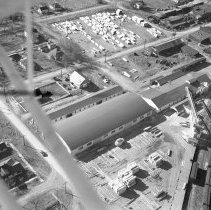
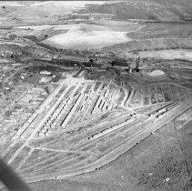
2019.1.107 - Aerial view of Baker City. W side of Baker City. Stockyards along RR track.
Aerial view of Baker City. W side of Baker City. Just off the left edge of the photo is the U.P. Depot. You can see the Broadway St. with a bend at the left, where it detoured around the depot. Above the bend are the stock-holding pens on the W side of the U.P. track, which is just outside the photo. In the middle of the photo is where the Sumpter Valley Railway engines could get turned around to head back along the SVRy line,which at one time ...
Record Type: Photo
-
2019.1.108 - Aerial view of Baker City. W side of Baker City. SVRy engine turnaround.
Aerial view of Baker City. W side of Baker City. At the upper left you can see Broadway St. making a detour around the U.P. Depot. In the middle left of the photo is where the Sumpter Valley Railway engines could get turned around to head back along the SVRy line,which at one time went all the way to Prairie City in Grant County. The two white buildings at upper left are Crabill and Columbia hotels just across 11th St. from the depot.
Record Type: Photo
-
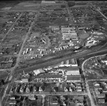
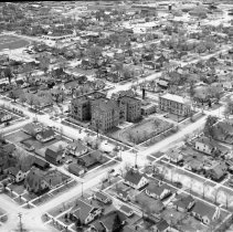
2019.1.109 - Aerial view of Baker City. St. Elizabeth Hospital, NE corner.
Aerial view of Baker City. St. Elizabeth Hospital, NE corner. In the upper left of the photos is the Baker High School, first occupied in 1917. In front is the athletic field that served both the junior high and senior high students. Can you locate the Columbia and Crabill hotels and the U.P. depot at the end intersection of 11th St. and Broadway?
Record Type: Photo
-
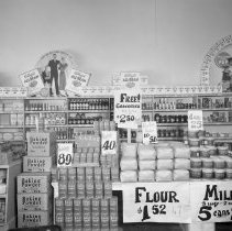
2019.1.11 - Unknown grocery store interior.
Unknown grocery store interior. Check out the prices. 4 rolls of toilet paper, e.g., 25 cents.
Record Type: Photo
-
2019.1.110 - Aerial view of Baker City. St. Elizabeth Hospital, NE corner.
Aerial view of Baker City. St. Francis Academy and Cathedral. Behind the Cathedral sits the James W. Virtue house, which used to occupy the Academy lot facing Church St. When ex-sheriff and banker Virtue left Baker City in 1893, the Catholics added a large three-story addition and turned it into a Catholic school, including dormitory for Catholic children from outside of Baker City. From its temporary home behind the Cathedral and lacking the e...
Record Type: Photo
-
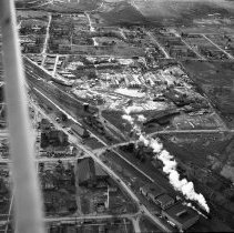
2019.1.111 - Aerial view of Baker City. Steaming locomotive at U. P. Depot.
Aerial view of Baker City. Steaming locomotive at U.P. Depot. Near the middle of the photo you can see the Crabill and Columbia hotels in front of the depot on 11th St. At upper edge of photo you can see some of the earliest houses built on Hillcrest.
Record Type: Photo
-
2019.1.112 - Aerial view of Baker City. Steaming locomotive at U. P. Depot.
Aerial view of Baker City. Steaming locomotive at U.P. Depot. In the middle of the photo you can see the Crabill and Columbia hotels in front of the depot on 11th St. At upper edge of photo you can see some of the earliest houses built on Hillcrest. W of the U.P. Depot is the SVRy Depot. The U.P. Depot was demolished in 1973. About 20 years ago the SVRy Depot was moved to the E side of the tracks on 11th St.. a block N of Broadway St.
Record Type: Photo
-
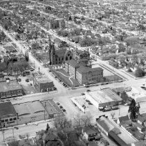
2019.1.113 - Aerial view of Baker City. U. P. Depot area.
Aerial view of Baker City. In the top third of the photo you can see the Crabill and Columbia hotels near the U.P. Depot on 11th St. W of the U.P. Depot is the SVRy Depot. The U.P. Depot was demolished in 1973. About 20 years ago the SVRy Depot was moved to the E side of the tracks on 11th St., a block N of Broadway St.
Record Type: Photo
-
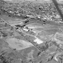
2019.1.114 - Aerial view of Baker City. Nascent Hillcrest and golf course.
Aerial view of Baker City. Nascent Hillcrest and golf course in middle and lower part of image. There are 2 images attached to this record. The first image has been darkened to highlight features in the very light negative. The building with the dark roof at bottom is the club house. At lower left corner is a very steep stretch of Indiana St. If you drove fast at the top, your car could gain a little air. About 2000 the city filled in making t...
Record Type: Photo